
Hurricane Lee downgraded to Category 3
Hurricane Lee is picking up intensity as a Category 3 storm as it whirls across the open Atlantic Ocean, with “additional strengthening” expected within the coming days.
Lee exploded to a Category 5 storm within 24 hours last week before slowing down and reorganizing over the weekend. Just behind Lee is Tropical Storm Margot, which is predicted to reach hurricane status by Monday afternoon.
Hurricane Lee is moving well north of Puerto Rico, the Virgin Islands and the northern Leeward Islands, though it still remains too early to determine whether the northeastern US coast and Canada could see any impacts, according to advisories from the National Hurricane Center on Sunday.
Life-threatening surf and rip conditions are expected along the East Coast, while dangerous swells generated by the storm are spreading to the Virgin Islands, Puerto Rico, Hispaniola, the Turks and Caicos Islands, the Bahamas, and Bermuda.
Lee’s historic intensification from an 80 mph Category 1 to a Category 5 with 160 mph winds last week makes it one the fastest-intensifying Atlantic storms on record. Warm waters are a potent fuel for hurricanes to gain strength, a phenomenon expected to accelerate amid a growing climate crisis.
Key Points
Show latest update
Atlantic to see two simultaneous hurricanes as Margot strengthens
Hurricane Lee is expected to continue to gain strength as it cruises across the Atlantic Ocean, and just behind it is Tropical Storm Margot, which forecasters predict will reach hurricane strength today.
Tropical Storm Margot became the 13th named storm after forming on Thursday evening, but it was far out in the Atlantic and posed no threat to land. It was last spotted about 1,185 miles (1,910 kilometres) west-northwest of the Cape Verde Islands late on Sunday night. Its winds stood at 65 mph (100 kph) and it was moving northward at 8 mph (13 kph).
It’s unclear what path they will take in the coming days, and whether they will pose a threat to the East Coast.
But they could get close enough for a phenomenon called the Fujiwhara effect, in which two storms rotate around each other and spin in the same direction. The National Weather Service describes it as “an intense dance around their common center.”
The phenomenon occured with hurricanes Hilary and Irwin in the East Pacific in 2017.
Stuti Mishra11 September 2023 21:00
‘Rapid intensification’ of storms likely to accelerate with warming waters
Hurricane Lee is in rare company. Only two recorded storms – Hurricane Wilma in 2005 and Hurricane Felix in 2007 – strengthened faster than Lee over a 24-hour period, as Lee developed from a Cat 1 to a Cat 5 last week before degrading into its current Cat 3 status.
The storm is predicted to continue to regain strength after slowing down over the weekend.
Brian McNoldy with the University of Miami told NBC News that the warm conditions in the Atlantic were ripe for the storm’s rapid intensification last week.
The “vertical wind shear was very low and the water temperature under it was very warm,” he said, adding that Lee “took full advantage of both.”
Last year, Hurricane Ian rapidly intensified over two separate periods before striking Florida. Hurricane Idalia recently strengthened from a Cat 1 to a Cat 4 within 24 hours.
“It’s a huge problem, and the past is not a good guide to what we should expect going forward,” Jeff Masters, a former hurricane scientist with the National Oceanic and Atmospheric Administration, told NBC.
Alex Woodward11 September 2023 20:30
New England watching Hurricane Lee as flooding, rain soak region
New Englanders are watching the current course of Hurricane Lee, as some spaghetti models predict the storm may be on a collision course for the region.
Though Hurricane Lee will likely arrive as a weaker storm by the time it reaches the northeast, it will land just on the heels of a wet weekend. Flooding has been reported in Rhode Island — and more is forecasted for the region today — while Maine experienced heavy rains late Sunday.
If the storm does turn into New England and the Canadian east coast, it will at very least bring with it high winds, dangerous rip currents, significant surf, and likely more rain for the region.
Graig Graziosi11 September 2023 20:00
Watch: Footage from inside the NOAA’s flight into Hurricane Lee
The NOAA sent a “hurricane hunter” aircraft into Hurricane Lee on Sunday night to gather data on the now Category 3 storm churning in the Atlantic.
The agency filmed a portion of the flight, which shows the researchers being jostled back and forth by the storm’s sustained 120mph winds.
Hurricane Lee is expected to remain a powerful hurricane until midweek, when forecasters believe it will begin to weaken.
Graig Graziosi11 September 2023 19:30
Hurricane Lee generates 15 foot waves
Hurricane Lee reportedly has generated 15 foot waves as it moves north of the Caribbean and into the waters off the US east coast, according to the Associated Press.
High surf and dangerous rip currents have already begun for some southeastern US states as the Category 3 hurricane continues on its trajectory further north.
Graig Graziosi11 September 2023 19:00
Dangerous rip currents caused by Hurricane Lee begin to affect southeast US
Forecasters have warned for days that Hurricane Lee could produce dangerous rip currents on the US east coast, and those predicitions have come to pass.
The National Hurricane Centre reported Monday morning that dangerous rip currents — which can drag swimmers out to sea — have begun in the southeastern US.
“Dangerous surf and rip currents have begun to affect portions of the southeastern U.S. coast, and these conditions are forecast to spread northward along much of the U.S. East Coast during the next couple of days,” the centre warned.
Swimmers in southeastern US states should consult their local weather information providers before heading out for a swim over the next few days.
Graig Graziosi11 September 2023 18:30
2023 sets the record for number of billion-dollar climate disasters
The NOAA has identified 23 seperate climate and weather disasters in 2023 that caused at least a billion dollars in damages, according to the agency.
Those events include Hurricane Idalia, which struck Florida’s western shoreline near Big Bend in late August, the devastating wildfire on Maui that killed more than 100 people, and a number of lesser reported but still highly damaging weather and climate disasters.
Severe storms, tornadoes, and hail blasted the Plains states in the spring, while California saw record breaking floods between January and March.
“There have been 23 confirmed weather and climate disaster events this year, each with losses exceeding $1bn. These disasters consisted of 18 severe storm events, two flooding events, one tropical cyclone, one winter storm and one wildfire event,” the NOAA reports. “For this year-to-date period, the first eight months of 2023 rank highest for disaster count, ahead of 2020 with 16 disasters. The total cost of these events exceeds $57.6bn, and they have resulted in 253 direct and indirect fatalities.”
An NOAA map detailing the 23 climate and weather disasters that caused at least $1bn in damages in 2023
(NOAA)
Graig Graziosi11 September 2023 18:00
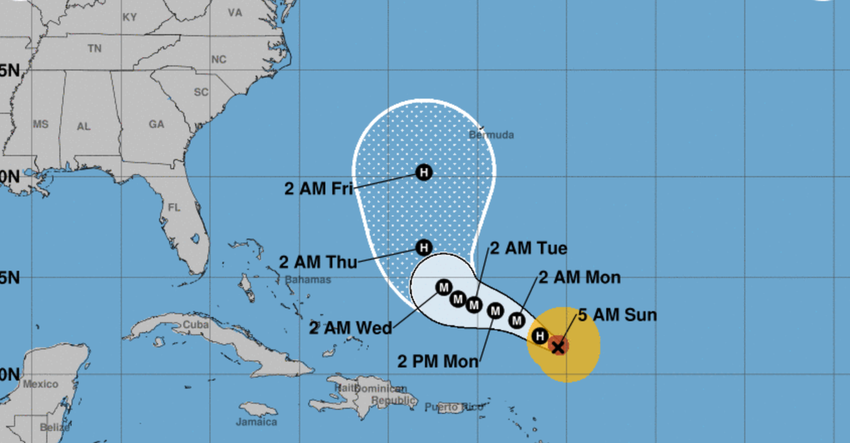
Hurricane Lee is expected to gain strength for the next two days before gradually weakening as the the week wears on, according to the National Hurricane Centre.
The storm is expected to pass near Bermuda on its way north.
The centre said the hurricane’s impact on the US east coast and Atlantic Canada is still unknown. Some spaghetti models of show Hurricane Lee skirting close to the coast, others place it further out in the Atlantic.
“Some strengthening is forecast over the next day or so, followed by gradual weakening. Hurricane-force winds extend outward up to 75 miles (120 km) from the center and tropical-storm-force winds extend outward up to 185 miles (295 km),” the National Hurricane Centre said in an 11am EST update.
Graig Graziosi11 September 2023 17:34
Tropical Storm Margot expected to become a hurricane tonight as path remains uncertain
“At 900 AM GMT (0900 UTC), the center of Tropical Storm Margot was located near latitude 25.3 North, longitude 40.0 West. Margot is moving toward the north near 8 mph (13 km/h), and this general motion is expected to continue during the next several days,” the National Hurricane Centre said in an advisory.
Forecasters are expecting it to gain strength over the next 48 hours. The storm’s winds are currently peaking around 65mph (104km/h).
Graig Graziosi11 September 2023 17:11
Hurricane Lee’s late-week impact on US east coast, Canada, still unknown
Hurricane’s Lee’s potential late-week impact on the US east coast and Canada is still unknown, according to the National Hurricane Centre.
“It remains too soon to know what level of impacts, if any, Lee might have along the U.S. East Coast and Atlantic Canada late this week, especially since the hurricane is expected to slow down considerably over the southwestern Atlantic,” the centre said on Monday.
It did note, however, that high surf and rip currents were still likely along the coast.
Graig Graziosi11 September 2023 16:27